|
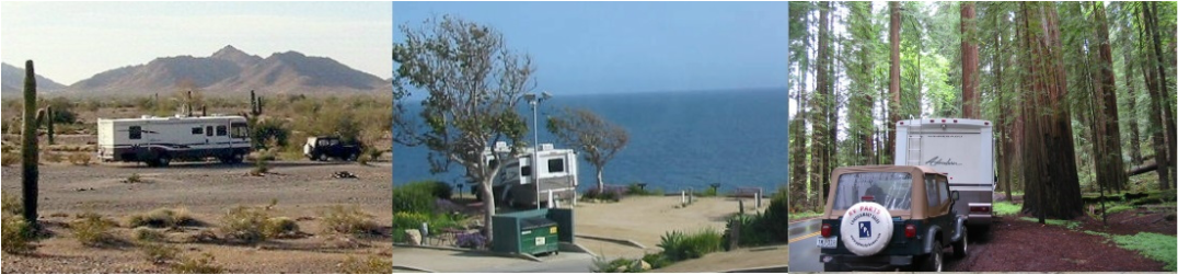
Before I begin our report on San Francisco, I must comment about a couple of things I left out of the Monterey/Carmel report. First, ML spotted about 3 whales cruising off the coast. We even saw the famous tail come out of the water, but pretty far away. Second, one of our astute readers reminded us that Clint Eastwood was mayor of Carmel for awhile. OK. On to San Francisco. Here's a map with generally the route we took. Our RV park is at the red 7 in Pleasanton at the right. 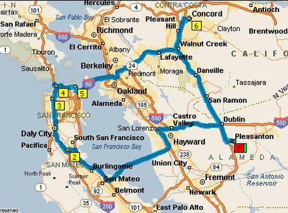 Our first stop was at #2, the Golden Gate National Cemetery to visit the grave of FADM Chester Nimitz, Pacific Commander in WWII.  Then we happened into Golden Gate Park, which is a large pretty park. We drove through rather quickly. We heard on the news that there was to be a Marijuana 'Smoke-In' that afternoon. We missed that, but we had the feeling that this town was always protesting, demonstrating, or 'raising awareness' something. Here are a few scenes of the park.    We drove through the Presidio, a fort overlooking the south end of the Golden Gate, established in 1776 to help defend the entrance to the harbor. Wait... 1776? We were just getting our independence? It was Spanish explorers who established the fort. We drove around a bit but didn't find the main part so no pictures. There was a lot of construction going on and they had moved the visitors center and we didn't find that either. We did find a viewpoint for a couple of pictures. 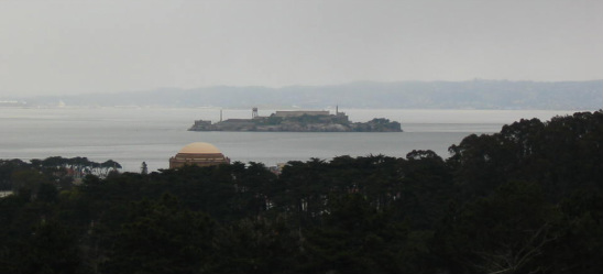 This is Alcatraz island, or 'the Rock'. It first was a fort for harbor defense and the the famous Federal Penitentiary.  Houses on the hillside. As you may know, San Francisco is noted for it's hills. Some streets are so steep I don't know how people park on them. Below is a photo that is reminiscent of our back-roading in Quartzsite. We knew the street was going to go down, but all of a sudden it just dropped away. The picture doesn't give the feel of how steep it was.  One of the more famous hills is a section of Lombard street that is well known for the one block of switchback curves. People live on this stretch. Note the garage in the second picture.   Looking further down Lombard street (and back up again) we see another of San Francisco's famous hills, Telegraph Hill with the Coit Tower atop. In the early days a system of semaphore flags was on this hill to signal the townspeople of ships entering the harbor.  Next is a view of the curvey part (in the distance) of Lombard from the other side. Note all the cars coming down. Also note the row houses on the right. These were everywhere, and in some areas they were painted in different colors.  The view from the top of the Coit tower was, of course, stunning. Unfortunately we had an overcast day which didn't yield the best pictures. The building with the 'wings' is the Transamerica Pyramid and is the tallest in town.   The Ferry Building with the Oakland-Bay Bridge in the background.  Looking west, the Golden Gate Bridge in the distance (also Lombard Street). Many of the rooftops below had decks and patios. California in general and San Francisco in particular is the origin of many 'progressive' (translate 'wild and wacky') ideas. The 'green' movement is very big out here and recycling/conservation/hybrid cars are everywhere. I'm all for conservation, but the following thing does not make a lot of sense to me.  No, it is not a passport photo booth. It's a one-person-at-a-time toilet. Not only is it one person at a time, but there is a 55 second automatic cleaning cycle between each visit! When the cleaning cycle is finished (as indicated on a little display screen), the next person pushes a button and the door on the right rotates open.   I just don't see any conservation here with all that cleaning and power usage between each use. Go figure! Another San Francisco landmark is Fisherman's Wharf. This is a busy place. We just drove by.   Mary Lou got out to take a picture and of course, found a new friend. A visit to San Francisco would not be complete without seeing the cable cars. These are little trolleys that run on tracks and are pulled up the hills by cables under the road bed. The cables are always moving and the cars 'grab' the cables to move up the hill. We had ridden them before, so we didn't do that this time. All we have is a picture of them below. There happens to be two in the picture, but they are individual cars.  There are many different means of public transportation here. The locals don't right the cable cars, but there are also trolleys (electric,runs on tracks, power from wires above) and electric buses (no tracks, power from wires above), and the BART (Bay Area Rapid Transit) which is high-speed rail. (More on that in the next report).  Trolleys. Note the pole coming off up to the left to grab the wire. One is at the other end for when the car goes the other way.  Electric Bus. Note the poles going off to the right to the wires above. The poles swivel as the bus maneuvers in the various lanes. Another important feature of San Francisco is Chinatown. The Chinese population here goes back to the 1860's when Chinese laborers were imported to help build the first transcontinental railroad. We would have liked to walk around there a bit, but we were tired and toward the end of the day. Parking is a problem here, too. This is the main entrance to the area.  This has been a long day. We need to rest up for tomorrow when we visit Alcatraz
Stay tuned.
4 Comments
|
Who Are We?
Chuck and Mary Lou have been traveling in their RV since 2002 and have lately been taking longer, extended trips. This is our way to share our experiences.  Trip Reports
All
|
 RSS Feed
